


Courboyer 9.5

togolo28
Gebruiker
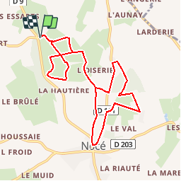

Lengte
9,5 km

Max. hoogte
210 m

Positief hoogteverschil
184 m
Km-Effort
11,9 km

Min. hoogte
150 m

Negatief hoogteverschil
184 m
Boucle
Ja
Datum van aanmaak :
2014-12-10 00:00:00.0
Laatste wijziging :
2014-12-10 00:00:00.0
2h35
Moeilijkheid : Gemakkelijk

Gratisgps-wandelapplicatie
 SityTrail
IGN / Geografische instituten
SityTrail Plus
De wereld gaat voor u open
Over ons
Tocht Stappen van 9,5 km beschikbaar op Normandië, Orne, Perche en Nocé. Deze tocht wordt voorgesteld door togolo28.
Plaatsbepaling
Land:
France
Regio :
Normandië
Departement/Provincie :
Orne
Gemeente :
Perche en Nocé
Locatie:
Nocé
Vertrek:(Dec)
Vertrek:(UTM)
327405 ; 5363097 (31U) N.
Opmerkingen